FastZone — Sales and Territory Management
S&T · Sales and Territory Management. Smart zoning and route optimization: create, balance and optimize your delivery territories in seconds, with an interactive map, real road routing and travel time between visits calculated by mode of transport (car, motorcycle or on foot).
What is FastZone?
Geospatial zoning plus interactive visualization, to design territories with precision and speed.
FastZone is a smart zoning and route optimization platform built for distribution and logistics companies. It combines advanced geospatial clustering algorithms with interactive map visualization, letting you create, analyze and adjust delivery territories quickly and on the basis of data.
From thousands of stops on a map down to the detail of a single customer, FastZone lets you design the right scenario, balance the workload and optimize the visit sequence — all in one tool.
- 3 zoning algorithms plus free manual editing
- Balancing by customers, weight, volume and revenue
- Route optimization over real roads with our own engine
- Multi-scenario, multi-organization, persisted in the database
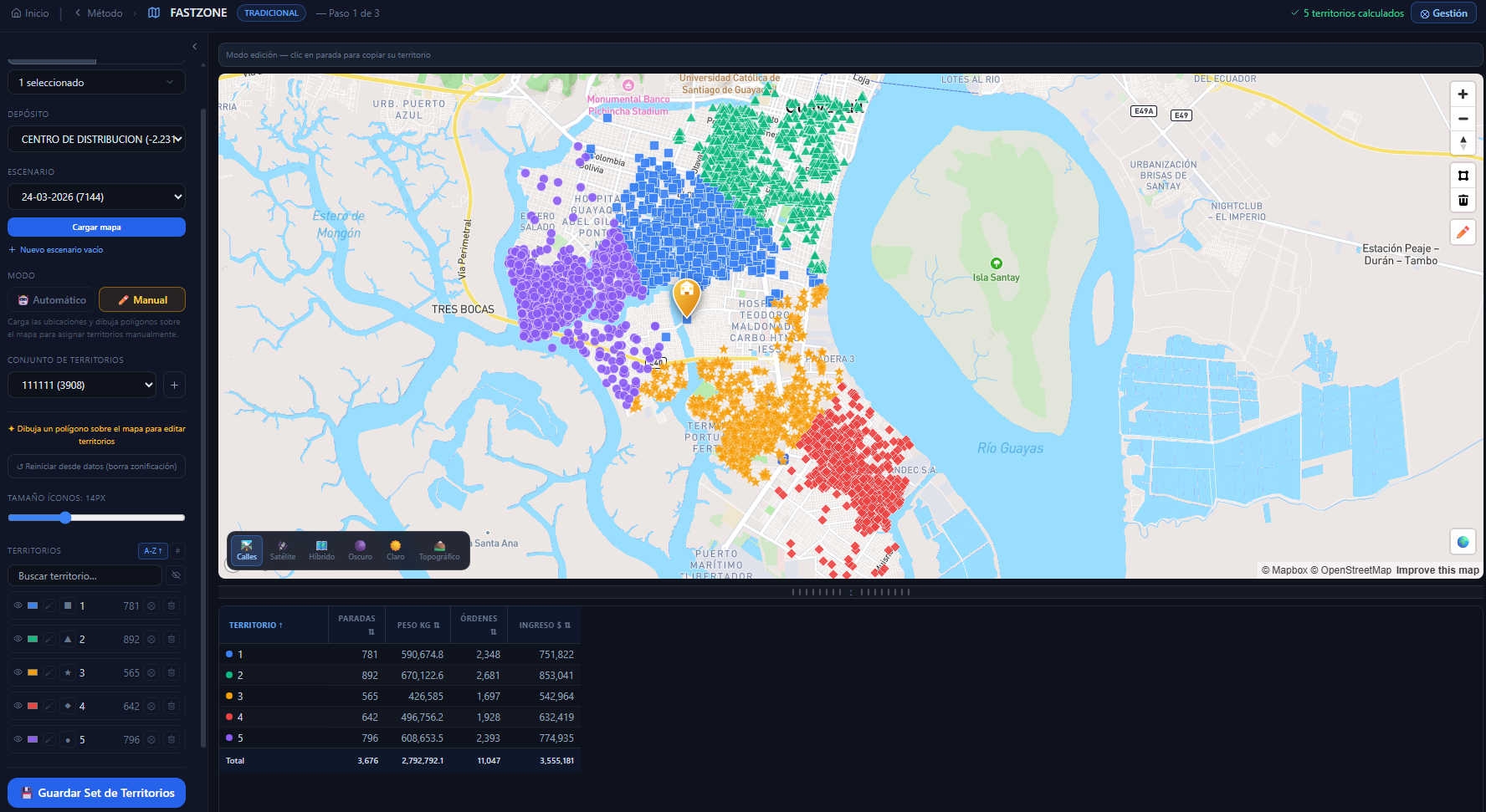
Main view · territories on a real map plus a KPI table by zone
From imbalance to balance, automatically
FastZone redistributes the stops until every territory is balanced by the mix of variables you choose.
Workload by territory (customers · weight · volume · revenue)
Automatic zoning
Three algorithms to generate territories in seconds.
Cluster
It groups stops by geographic proximity (geospatial K-means). Ideal for compacting dense areas.
Radial
It divides the area into angular sectors from a central point, like slices of a pie from the depot.
Compact
It minimizes each zone's internal spread to produce more homogeneous, compact territories.
Set the number of territories freely (minimum 2), work with multiple scenarios (draft and approved) and reuse territory sets. Need to split further? Subdivide any territory into N sub-territories with the same engine — they automatically inherit the parent territory's icon.
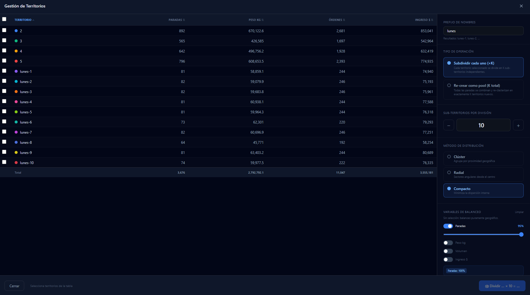
Territory management · subdivision, distribution method and balancing variables
Workload balancing across 4 variables
Balance territories with a weighted mix — the percentages add up to 100%.
Example mix: 40% Customers + 30% Volume + 30% Revenue. FastZone calculates the optimal distribution honoring that ratio, so no rep and no route ends up overloaded.
A genuinely interactive map
6 base maps, 10 icon shapes, colors by visit day and real routes over streets.
6 base maps
10 icon shapes per territory
Colors by visit day
Real routes or sequence
Draw routes along real streets, or as a straight-line sequence between stops, whichever you prefer.
Controls to your taste
Zoom, compass, icon size, Street View in one click, and color toggling by territory or by visit day.
Everything persists
Icon size, column order and width, and panel state are saved per user and restored in every session.
Manual editing, completely free
The algorithm gets you close; you give it the final touch.
Lasso
Draw freely by dragging the mouse to select a group of stops. Ideal for quick adjustments.
Polygon
Outline exact zones by clicking vertex by vertex, for precise control of the territory.
Create, reassign and paste
Create a new territory on the fly, reassign stops to an existing one, or copy stops from one territory to another.
From the territory list: subdivide, manage several at once, hide or show zones (one by one or in bulk), search in real time and collapse the side panel — all with your settings saved.
In-depth analysis and KPIs
Every decision backed by clear metrics and charts.
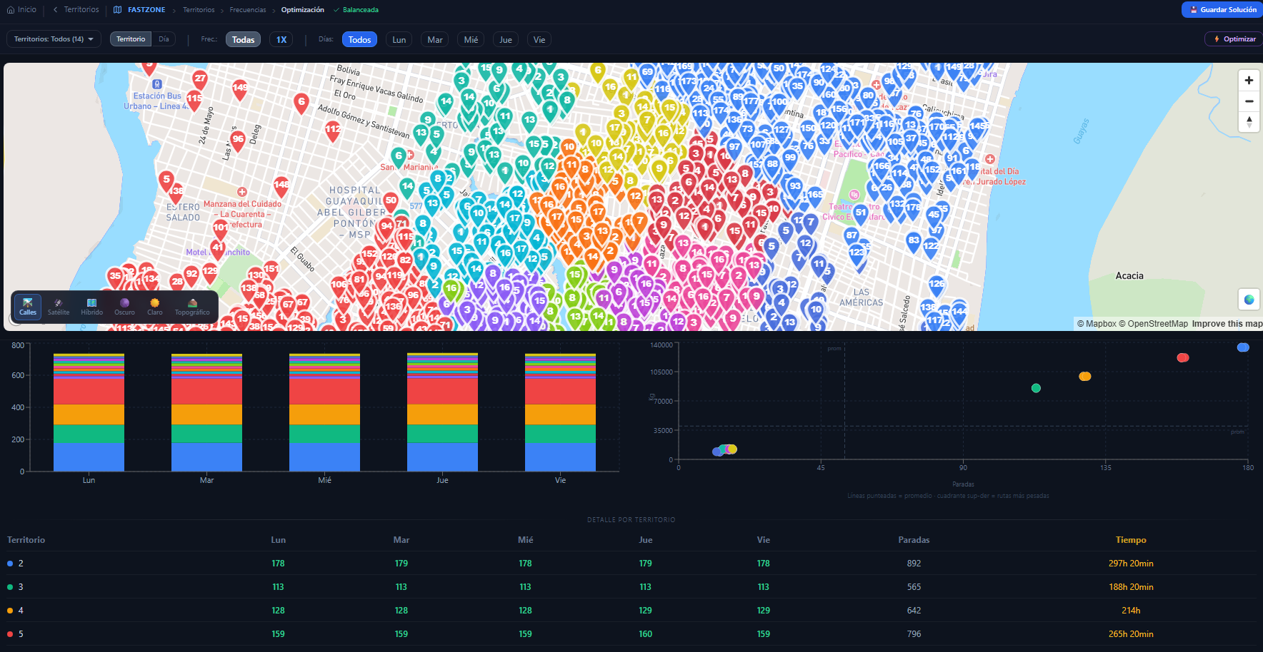
Balanced map plus balance charts, proportion donut and dispersion by territory
Table by territory
Stops, total weight, orders and revenue by zone. Sort by any column and adjust widths — saved per user.
Balance charts
Balance bars across territories, a stops/volume proportion donut and distribution by visit frequency.
Detail by stop
Metrics for distance, travel time and stops per route, plus the full detail of each selected customer.
Visit frequencies
Zoning that honors each customer's visit cycle.
FastZone supports frequency codes per stop, so planning honors how often and on which days each customer is visited.
- Filter the map by a specific frequency
- See the distribution of frequencies in charts
- Include frequency in territory balancing
- "Territorial Frequency" method: zoning that honors visit cycles
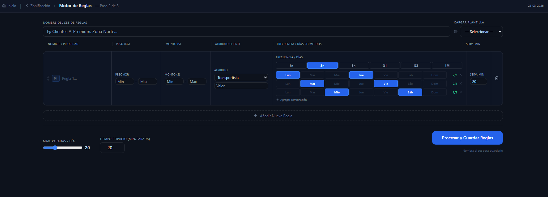
Rules engine · frequencies, allowed days and customer attributes
Optimize the sales force
Real road routing and travel time based on how your team actually moves.
Our own optimization engine assigns the visit day and the optimal sequence of every stop, calculating distances and times over real roads, not in a straight line.
And here is what matters for your sales force: depending on whether the rep travels by car, motorcycle or on foot, FastZone uses the matching speed to calculate the real time between visits and build the most efficient sequence for the day.
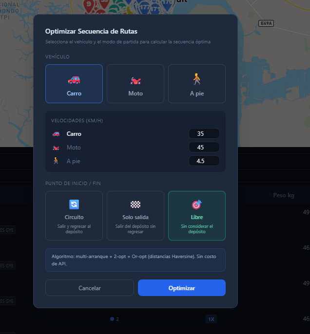
Optimize sequence · choose vehicle, speed and start/end point
Car
35 km/h
For large territories and intercity routes.
Motorcycle
45 km/h
Nimble in urban traffic and high-density areas.
On foot
4.5 km/h
For pedestrian areas, markets and micro-routes.
Set the working days (1–7), the depot mode (round trip, outbound only or open) and the speed. FastZone returns the visit day, the optimal sequence, total distance (km) and estimated time (hours) per route and per day.
Multi-scenario: compare, save and approve
Try different configurations before publishing the final plan.
Work with several scenarios per organization, in draft y approvedstates. Save complete solutions (territories plus frequencies plus optimization), compare them and, when you are ready, approve: FastZone transfers the assignments to the final territories and persists icons and colors in the database.
- Saved, reusable solutions
- Territory sets with a name, color and depot
- Multi-organization: data isolated per company
- SQL Server with Logistics and Planning schemas
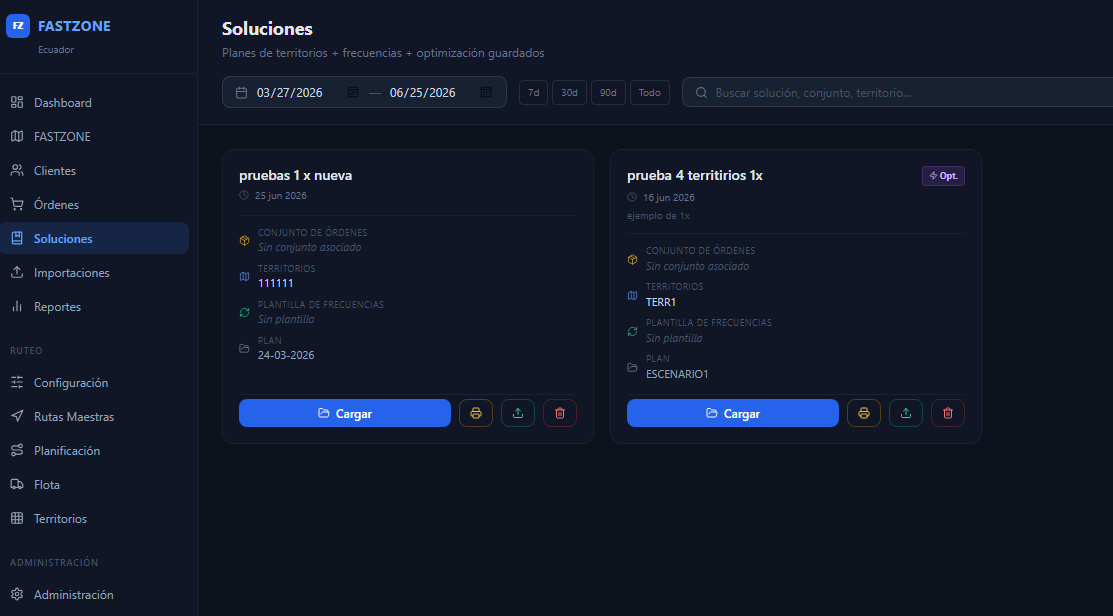
Saved solutions · plans for territories, frequencies and optimization
A guided workflow
From the data to the approved plan in four steps.
Selection
Choose the scenario, the territory set and the planning method (Traditional, Radial, Territorial Frequency or Concentric Rings).
Zoning
Set the method and the balancing variables, and generate the territories automatically.
Review
See the result on the map, edit by hand and adjust the territories to your judgment.
Optimization
Optimize the daily routes, review the KPIs and approve the final plan.
Key benefits
Why distribution teams choose FastZone.
Time saved
Automatic zoning in seconds, against days of manual work.
Fair balancing
Distribution by any combination of stops, volume, weight and revenue.
Flexibility
3 zoning algorithms plus completely free manual editing.
Full visibility
6 base maps, 10 icons, colors by day and real routes over streets.
Optimized routes
Our own optimization engine for the most efficient sequence over real roads.
Deep analysis
KPIs, balance charts, frequency analysis and detail by stop.
Full persistence
Icons, colors and assignments are saved to the database on approval.
Multi-scenario
Compare and approve different scenarios before publishing.
A pleasure to use
Persisted preferences, a collapsible panel, and lasso and polygon tools.
Frequently asked questions about FastZone
What people ask us most about zoning and route optimization.
What is FastZone?
FastZone is a smart zoning and route optimization platform for distribution and logistics companies. It combines geospatial clustering algorithms with interactive map visualization to create, analyze and adjust delivery territories with precision and speed.
How does FastZone balance territories?
With a weighted mix of up to 4 variables: number of customers (stops), order weight, cubic volume and revenue. You assign a percentage weight to each (they must add up to 100%) and FastZone calculates the optimal distribution honoring that ratio.
What zoning methods does it offer?
Three algorithms: Cluster (geographic proximity with K-means), Radial (angular sectors from a central point) and Compact (minimizes internal spread). Plus manual editing with lasso and polygon tools.
Does FastZone optimize routes?
Yes. It uses our own optimization engine to assign days and optimal sequences, calculating distances and times over real roads, not in a straight line.
Does it calculate time between visits by mode of transport?
Yes. To optimize the sales force you choose the mode of transport — car, motorcycle or on foot — with its configurable speed, and FastZone calculates the real travel time between each visit to build the most efficient sequence.
Can I work with several scenarios and companies?
Yes. FastZone is multi-scenario (draft and approved) and multi-organization: the information is isolated per company, and when you approve a scenario the assignments, icons and colors are persisted in the database.
Design better territories and more profitable routes
We will show you FastZone using a real scenario from your operation.
Request a FastZone demo