FastTrip — Route Optimizer
Optimal routes in seconds for hundreds or thousands of stops. Our own optimization engine calculates over real streets, honors your time, capacity and break constraints, and always works with modern, up-to-date mapping.
Real power behind every route
Our own multi-layer optimization engine, producing optimal routes in seconds.
FastTrip is the platform's route optimizer. At its heart is our own multi-layer optimization engine , which groups the stops, orders them by real road distance and minimizes distance and time while honoring every constraint you set.
It generates optimal routes in seconds for hundreds or thousands of stops. And if one layer of the process hits a difficult scenario, the engine automatically steps down to the next level — so it always produces a valid result.
- Routes over real streets, not straight lines
- Hundreds or thousands of stops in seconds
- Time, capacity and break constraints
- A robust engine: it always returns a route
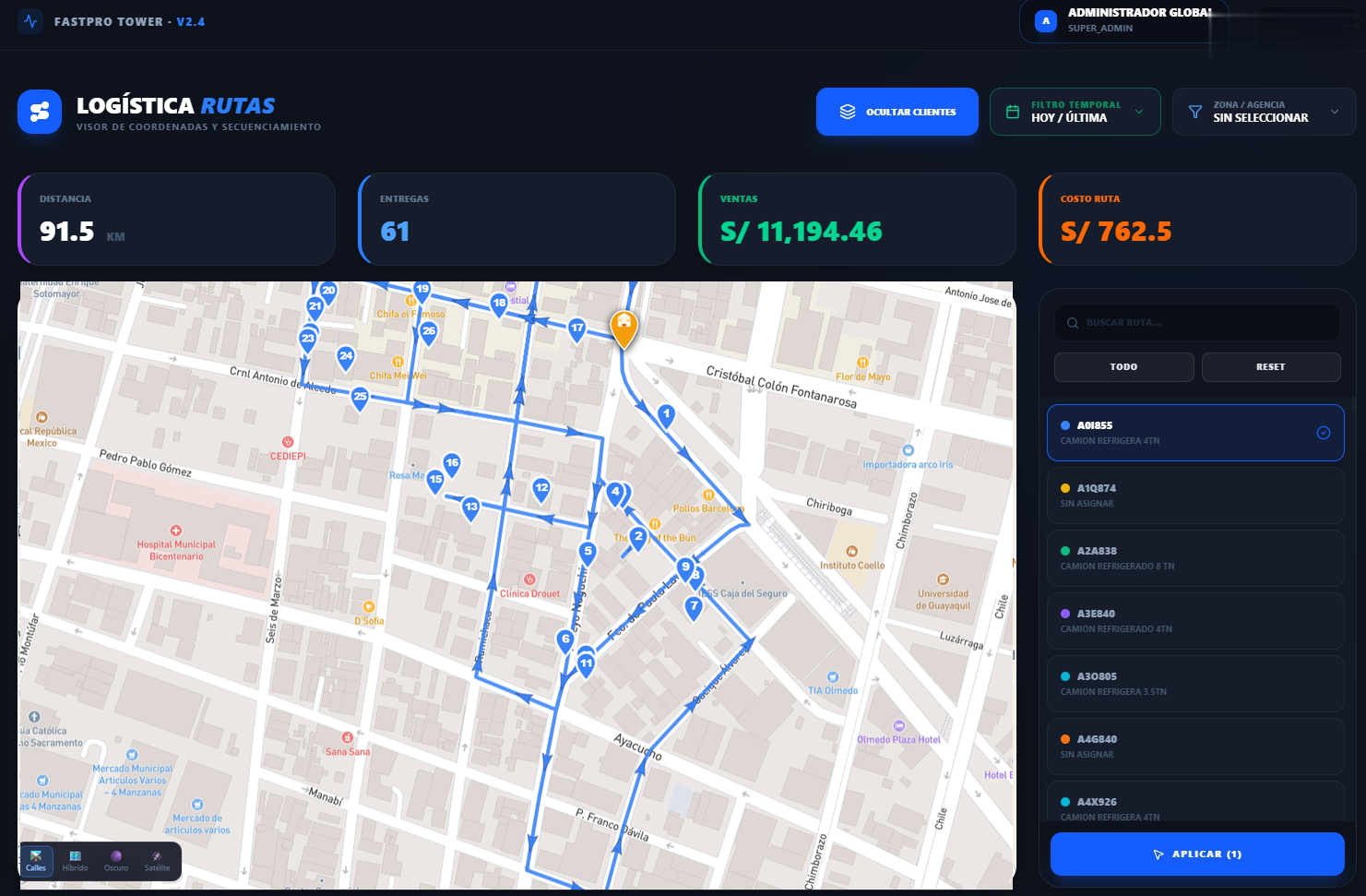
Optimized routes by color, following the city's real streets
How the engine works
Three specialized layers working in sequence.
Clustering
Our own algorithms form stop groups by proximity, in radial sectors or in compact zones, whichever suits.
Sequencing
It orders each group's stops by real distance over the road network, not in a straight line.
Global optimization
It minimizes distance and time while honoring every constraint, then applies a local optimization that removes crossings and inefficiencies.
A mechanism of graceful degradation: if a layer hits a case it cannot solve, the engine automatically falls to the next level — always guaranteeing a result, even in the most complex scenarios.
The optimizer at work
The vehicle follows the optimal sequence: each stop turns green as it is visited.
Routing parameters
The configuration profile that controls how routes are calculated and bounded — reusable as a scenario.
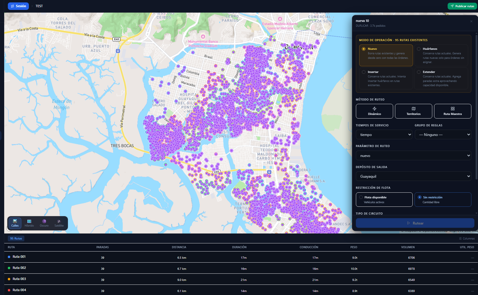
Routing configuration panel over the full universe of stops
Capacity and workday
| Capacity factor | % of nominal capacity that is usable |
| Preparation time | Fixed time before starting each route |
| Maximum driving | Maximum driving hours per route |
| Delivery time | Base time for each delivery |
| Helper time | Extra time when the route carries a helper |
Dispatch
| Preferred time | Target departure time from the depot |
| Dispatch windows | Permitted time windows for departure |
| Allowed delays | Maximum delay before and after schedule |
| Pre-route time | Vehicle preparation before departure |
| Post-route time | Settlement and return after completing the route |
Driver breaks
| Maximum breaks | How many the driver can take per route |
| Duration | Minutes per break |
| Interval | Driving hours before the next break |
| Reset | Counter reset on arrival at the depot |
Route limits
| Maximum routes | Maximum number of routes to generate |
| Maximum distance | Maximum kilometers per route |
| Max customers / stops | Unique customers and total deliveries per route |
| Maximum total time | Maximum duration of the full workday |
Rush hour and multi-day
| Rush AM / PM | Rush hour time ranges |
| Degradation factor | % speed reduction at rush hour |
| Maximum days per route | For routes that run longer than one day |
| Layover | Time window for overnight stops |
Fleet and modes
| Fleet mode | Available vehicles only, or unrestricted |
| Circuit type | Return to depot or one-way |
| Speeds | Car 35 · Motorcycle 45 · On foot 4.5 km/h (configurable) |
| Order splitting | Splits large orders across several vehicles |
Rule-based service times
The time the driver spends at each customer, calculated from the order's attributes.
The variables that determine it
FastTrip automatically calculates each stop's service time from these attributes, to estimate the arrival time at every customer with precision.
Routing rules
Control who can deliver what, to whom and when.
Vehicle
- Vehicle zone: restriction to geographic areas.
- Customer types permitted per vehicle.
- Compatible product lines.
Load
- Goods mixing permitted or not.
- Temperature: chilled, frozen or dry.
- Assignment to vehicle compartments.
Order
- Time windows (strict or flexible).
- Fixed delivery sequence.
- Penalties for violating constraints.
Every rule can specify the weekly visit pattern (Mon–Sun) and predefined combinations based on the customer's frequency.
Routing methods
Five ways to plan, depending on your operation — and they combine with each other.
Dynamic
The tool decides how many trucks to use to meet the day's or shift's demand, generating the necessary routes automatically.
Master routes
Load stop sequence templates saved for routes that barely change — schools, government buildings, malls or fixed customers.
By territory
Create territories with any business rule (customer type, high volume, city areas) and FastTrip generates routes inside them. It can create several dynamic routes per territory, loosen by percentage how much goes into each one, and include or exclude territories from a route.
Manual
You draw a polygon on the map and FastTrip generates a route with every customer inside that area.
Mix
Combine the methods above in a single plan — for example, fixed master routes plus dynamic routes for the rest of the demand.
Orders that arrive later
When more orders come in, you keep the routes already built and create new routes for the orphan stops — or insert them and let the system decide which route they fit best.
Once generated, every route follows the real road network and is refined with a local optimization that removes crossings and inefficiencies.
Route visualization
Every route, stop by stop, on the real map.
Every route shows the ordered list of stops with sequence number, customer and code, address, estimated arrival time, service time, assigned day, frequency, weight, volume and revenue — plus custom attributes.
- Real route: the line follows the streets and roads exactly.
- Sequence: a schematic view in visit order.
- Color by territory or by visit day (7 colors).
- Street View built in: see the customer's exact location.
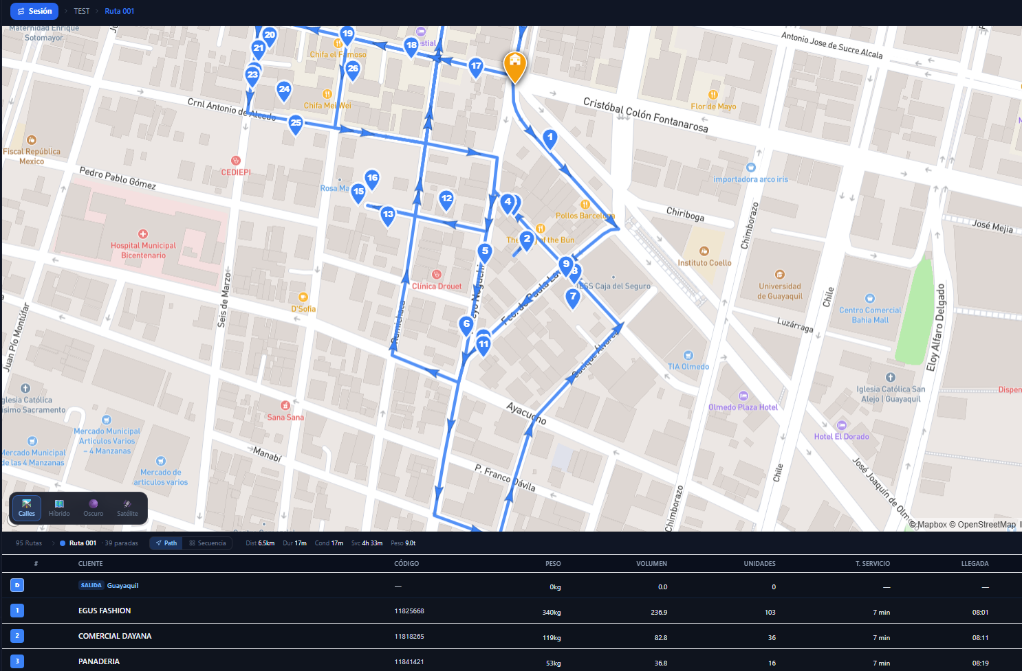
A real route over the streets, with its stop sequence and metrics
Recalculation and route administration
Adjust without losing the work: the engine recalculates only what it must.
Flexible recalculation
- Refine zoning and rebalance territories.
- Re-optimize visit sequences.
- Recolor a stop or reassign by polygon.
Merge and balance
- Merge two routes and recalculate the sequence.
- Redistribute stops, weight, time or revenue.
- It honors each vehicle's capacity.
Master routes
- Fixed route templates for recurring distribution.
- Predefined vehicle, schedules and stops.
- Bulk load by CSV and location search.
Planning sessions let you create, duplicate and compare scenarios (new route, orphans, insert, extend) without touching work in progress, and publish the optimal solution to the master data in one click.
Analytics, KPIs and reports
Metrics by territory and by day, ready to act on and to share.
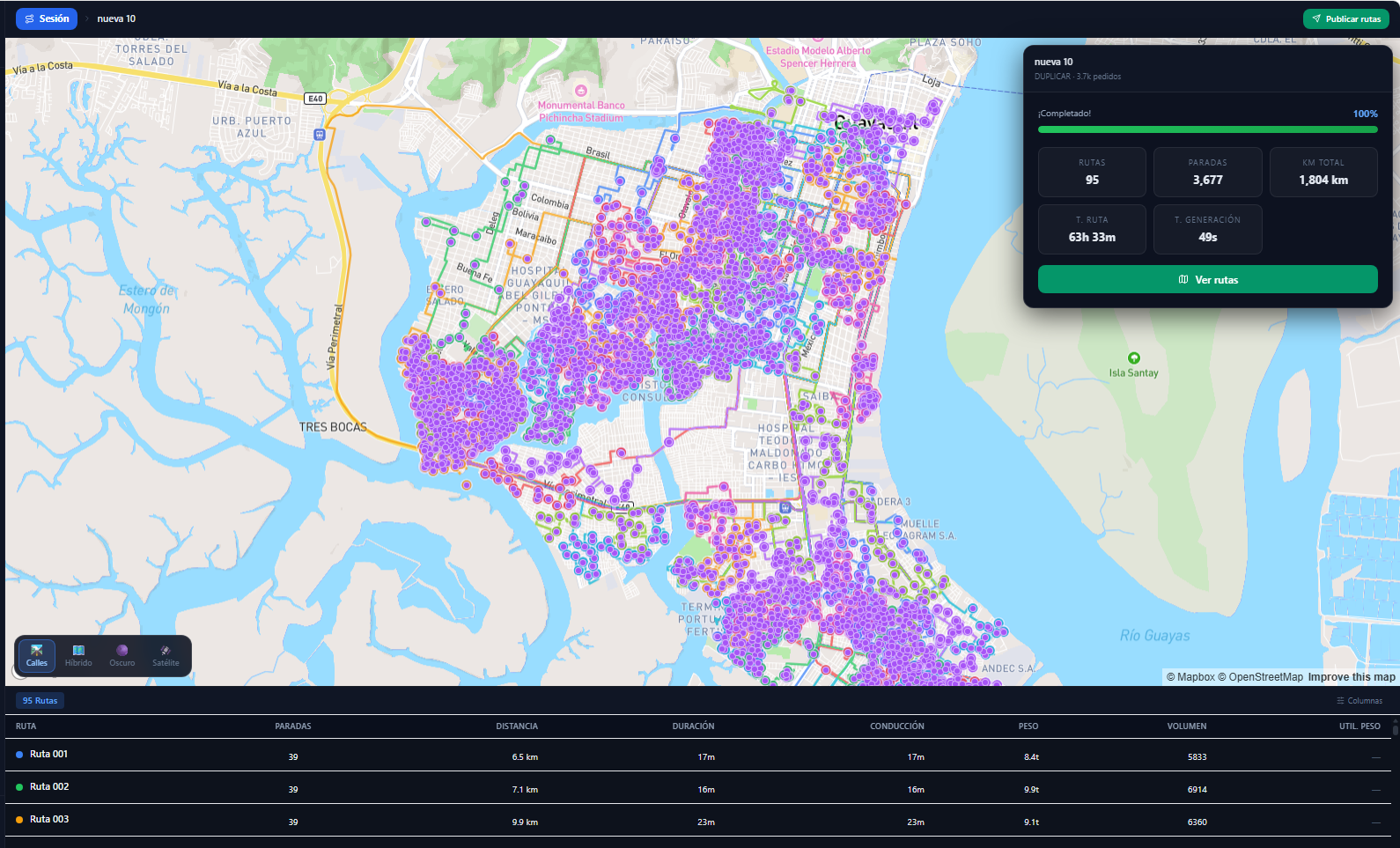
Optimization result · stops, distance and time per route
KPIs per route
Stops, distance, travel time, service time, revenue and weight — sortable by any metric.
Balance charts
Bars of stops by day and territory, stops versus volume dispersion, and a cost breakdown per route.
Export to Excel
Executive summary, detail of every stop and a route summary — in one file ready for operations and management.
Every result is saved as a named solution with its parameters, mode of transport and notes, to compare, restore or publish later.
Modern mapping, always up to date
Your team never manages a map file — everything updates on its own.
FastTrip uses Mapbox GL, one of the most advanced digital mapping platforms in the world — the same technology behind major global mobility and media platforms. Instead of image maps (raster), it uses vector tiles: sharp at any zoom, GPU accelerated and fully customizable.
- Sharp at any zoom level (it never pixelates)
- GPU rendering — smooth on any device
- Configurable styles, colors and layers
- Fluid map rotation in real time
Vector versus traditional maps
| Feature | Raster | FastTrip |
|---|---|---|
| Zoom | Pixelates | Always sharp |
| Load | Heavy images | Data only, GPU |
| Customization | No | Total |
| Rotation | Static | Fluid |
Map data that updates itself
Streets — OpenStreetMap
The road network is fed by OpenStreetMap, with more than 10 million global contributors and continuous editing. It is published on the platform monthly: new roads appear, one-way directions change and closed streets drop out of use.
Satellite — Maxar
The satellite view uses high-resolution imagery (down to 30 cm per pixel in urban areas), refreshed periodically. Check entrances, warehouses and industrial sites before you arrive.
Routing on a current road network
The routing engine uses its own road network graph based on the same open data, refreshed periodically: new streets, directions, turn restrictions and reference speeds.
6 map styles for every need
The result: the planner always works with the most current map available — no manual updates, no files to download, no maintenance. Zero as-the-crow-flies routes, zero phantom streets.
Key benefits
Why FastTrip moves the needle in your operation.
Speed
Optimal routes in seconds for hundreds of stops.
Road accuracy
Routes follow real streets, not straight lines.
A robust engine
A multi-layer chain that always produces a result.
Flexible constraints
Time, capacity, breaks, mixing and windows — all configurable.
Precise times
By customer type, goods, order and frequency.
Multi-day
Routes spanning more than one day, with layovers.
Current mapping
Maps and road network refreshed monthly, with no maintenance.
Excel reports
Ready to share with operations and management.
Direct publishing
From the optimal solution to the master data in one click.
Frequently asked questions about FastTrip
What people ask us most about route optimization.
What is FastTrip?
FastTrip is FastRoute's route optimizer. It generates optimal routes in seconds for hundreds or thousands of stops using our own multi-layer optimization engine, honoring constraints on time, capacity, driver breaks and delivery windows.
Do the routes follow real streets?
Yes. FastTrip calculates routes over the real road network, not in a straight line. Every route follows existing, passable streets and roads, with arrival times calculated from the real speeds of each road type.
Does it calculate time by mode of transport?
Yes. You choose the mode of transport — car, motorcycle or on foot — with its configurable speed, and FastTrip calculates the real travel time between stops to build the most efficient sequence.
How often are the maps updated?
The mapping is updated continuously by the global OpenStreetMap community and published monthly on the platform, with your team managing no map file at all. New roads appear and closed streets drop out of the calculation.
Can I export the results?
Yes. FastTrip exports Excel reports with several sheets: an executive KPI summary by territory and day, detail of every stop, and a route summary with distances, times and loads.
Does it handle routes with many constraints?
Yes. The engine honors time windows, vehicle capacity (weight, volume, units), maximum stops, maximum distance, driver breaks, driving time, rush hour and multi-day routes with layovers.
Shorter, cheaper, more realistic routes
We will show you FastTrip optimizing a real day from your operation.
Request a FastTrip demo